

Lost Winds (Lasuen) Beach
The Lost Winds beach has four volleyball courts and is a popular beach for sunlovers and families. This beach has been slowly narrowing, which isn't apparent in the profiles taken by the City consultant because every fall, the City pushes sand from adjacent beaches in front of the volleyball courts.

ARMORING: The beach is still wide enough here to provide good protection for the tracks,

UNIQUE CHALLENGES: This beach will not receive sand from the current Federal project, although it is likely that longshore drift will send some of that sand this way. This is one area in the City that has established some natural dune habitat on top of the OCTA revetment which could benefit from some rehabilitation.

SEDIMENT CHARACTERISTICS:  Generally medium-grain sand with occasionally gravel/cobble cusps.

INFRASTRUCTURE: Four volleyball courts and an at-grade pedestrian crossing at the railroad.

PUBLIC ACCESS: This is a public beach with vertical and lateral public access but no adjacent public parking.

SURF RESOURCES: are there any here?
The images below illustrate the evolution of Lost Winds (Lasuen) Beach 1972-2023 showing significant narrowing in the 1980s, followed by more gradual narrowing. The City’s winterizing program could result in the beach in front of the volleyball courts becoming wider at the expense of adjacent beaches.

Lost Winds 1972

Lost Winds 1989

Lost Winds 2004

Lost Winds 2019

Lost Winds 2021

Lost Winds 2023
The image below indicates vertical growth of the Lost Winds beach between 2001 and 2022, most likely due to the City’s program of “pushing” sand in front of the volleyball nets (the profile is located between two courts).

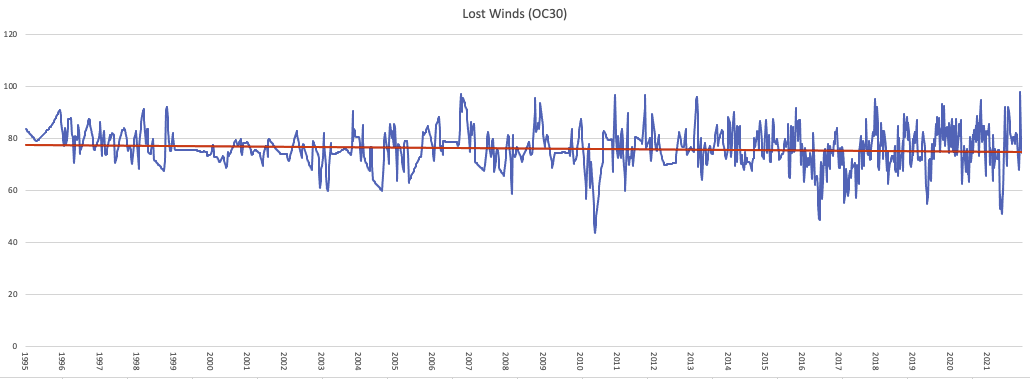
Below, data from UC-Irvine demonstrate the relative stability of this beach from 1995-2021.
Gallery of historical photos from Lost Winds beach prior to 2015. (these are place-holders, need to get better ones, maybe about nine total).


Another gallery of recent photos.